
Slapton Ley National Nature Reserve is a 214 Ha
site which includes the largest
natural lake in South-West England, Slapton Ley. It is managed by the Field
Studies Council (FSC) alongside Whitley Wildlife Conservation Trust, Natural
England (NE) and South Hams District Council. The site holds two designations
the first being as a Site for Special Scientific Interest (SSSI) and the second
designation as a National Nature Reserve (NNR). The site consists of a diverse
range of habitat which includes open water, sea shore, woodland, shingle ridge,
wetlands, grassland, headlands and cliffs (Trudgill et al. 1996). Figure 1 illustrates the general layout of the nature
reserve.

Figure
1 Map of Slapton Ley NNR
(Unknown 2010)
The landscape of Slapton Ley NNR
The key feature in the landscape of Slapton Ley NNR
is the Ley itself and is effectively split into two parts, the upper and lower
Ley. The lower Ley being the largest open water area is about 1 ½ Miles
long with the upper Ley being more or less completely filled in with silt which
supports areas of reed swamp and carr woodland (Benson-Evans et al 1967). The Ley although situated right on the coast
is fresh water and acts as a sink for surrounding streams including the River
Gara (Mercer, I.D.,1966). These inflows of freshwater along with direct
rainfall maintain water levels in the ley and on occasion cause it to overflow,
with rainfall being the biggest factor in the variation of the depth of the Ley over the year (Benson-Evans et al 1967). The NNR is broken up into
approximately 43Ha of Woodland, 98Ha of freshwater habitats, 34Ha of Shingle
and what’s left of the 214Ha site is made up of fields (Brookes & Burns 1969). The woodland is fragmented in and around
Slapton Ley NNR and as Figure 1 illustrates there are three main
areas of woodland: Slapton Wood, France Wood and Hartshorn Plantation. Slapton
Wood has a small tributary of the River Gara
known
as the Slapton Wood Stream running through it and the
woodland is classed in part as ancient woodland with no evidence of it having
been agricultural land at any point (Mercer 1966). Slapton Wood is dominated by Quercus robur (Pedunculate Oak), Castanea sativa (Sweet
Chestnut) and Fagus sylvatica (European Beech). France wood used to be
agricultural land pre 19th Century as maps from the 18th
Century clearly show no woodland and only fields in this area. The wood is
dominated by Quercus robur
(Pedunculate Oak), Castanea sativa (Sweet
Chestnut) and Carpinus betulus (European Hornbeam). Hartshorn Planation is
dominated by Pinus
sylvestris (Scots Pine) and Acer
pseudoplatanus (Sycamore).
The fields found in and
around Slapton Ley NNR are used for arable and livestock farming with some
partaking in various Agri-Environment schemes. These schemes are voluntary on
the farmer’s behalf but promote sound environmental practices which then allow
the farmer to be paid for doing so. The main schemes come in two modern forms
as Entry Level Stewardship and then Higher Level Stewardship with two main
older types Countryside Stewardship Scheme and Environmentally sensitive areas
(ESA). The Countryside Stewardship Scheme was replaced by the higher and lower
level schemes however those who signed up to the original scheme still operate
under it until it expires. One of the farms right next to the Slapton Ley Field
centre is on this scheme which expires shortly and as a result receives
payments for using environmentally sound methods such as set aside, leaving
field margins unmanaged and actively promoting wildlife within the farmland
itself (Little etal 1998). This
particular farm achieves the promotion of wildlife by encouraging Emberiza cirlus (Cirl Buntings) on the land through the use of set-aside, leaving field
margins to grow, and the use of mixed farming i.e. a mixture of arable and
livestock farming. The farm also works alongside the Slapton Ley FSC Study
Centre to aid in the education of students and enthusiasts alike in
conservation and good farming
practice.
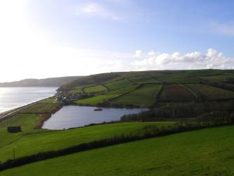
A view of the ley
The landscape of Slapton Ley and its surrounding
areas has changed throughout the centuries as has the demands that man has put
on the area. It appears from various studies that man began to turn woodland in
the Slapton Area into farmland during the mediaeval period (Foster, et al 2000) and gradually began to
intensify in agricultural use over the centuries. During the mediaeval period
field sizes were generally large and open however were worked or rather rented
in small strips by farmers (Titow 1965) who worked a particular strip of land
with live stock usually being communally grazed by commoners on common land
(Titow 1965) as we progress through the centuries and the old mediaeval feudal
manorial system becomes extinct, farmers begin to own their own fields and
further intensify production in fields.
Shooting
ahead to the early to mid 20th century and farmers begin to focus on
single products for a field focussing on productivity and getting the absolute
most out of each field (Leeuwis 2004) with little regard for the
environmental consequences of such actions which has led to the decline of a
number of species such as the aforementioned Emberiza cirlus.
This
intensification during the 20th century led to a massive increase in
the use of fertilizers, pesticides and herbicides which have seriously affected
and altered the ecology of areas such as Slapton Ley over the years however,
with the introduction of Agri-Environmental laws and policies to attempt to
curb the environmental decline and indeed reverse it things have taken a turn
for the better in and around Slapton Ley NNR as farms which have signed up to
various agri-environmental schemes have increased the conservation function and
value of their land.
The Ecology of Slapton Ley NNR
Slapton Ley NNR with its Mosaic of
habitats from wetland to woodland to grassland and shingle is home to a variety
of model ecosystems. Slapton Ley NNR is
also home to a variety of rare species such as Emberiza
cirlus (Cirl Bunting), Trifolium
scabrum
(Rough Clover), Muscardinus avellanarinus (Hazel Dormouse) and Corrigiola
litoralis (Strapwort).

The Slapton Sands Shingle Ridge (see Fig
1) is an area of ecological interest to many due to its proximity to both the
ocean and the ley which provides a unique and rich habitat for a variety of
rare plant species. T.Scabrum was
rarely found on the shingle ridge pre 1971 but after management was carried out
to prevent cars parking on the ridge as well as sealing off area of vegetation
on the shingle ridge it has since become established (Burns 1996). Another
species T.striatum (Knotted Clover)
was absent pre the beginning of management in 1971 and is now classed as
“occasional” in abundance on the ridge (Burns 1996). The shingle ridge that was
once fairly devoid of vegetation due to mismanagement is now mostly covered in
vegetation and requires both scrub management and mowing to help maintain the
botanical value of the ridge (Burns 1996).

Strapwort in flower
The ley itself is home to a diverse
range of flora and fauna both within the ley and around it. Around the ley the
rare plant C.littoralis can be found
although its distribution was very localised around the ley as a result of
scrub encroachment and the restriction of cattle around the ley itself (Burns
1996) it is now increasing in abundance thanks to efforts by Natural England
and the management team (plus Kew Gardens for providing seeds) and it is hoped
the abundance will increase further in the coming years (Burns 1996). Both Lustra lustra (European Otter) and Neovison vison (American Mink) are found
in and around the Ley. Studies on the prey of both species by Riley (1996) show
that while L.lutra take Cyprinids,
Eel, Perch and Pike, N.vison is
responsible for taking a majority of lagomorphs, Rodentia and birds. Myotis daubentonii
(Daubenton’s Bat) are regularly found skimming food off of the ley surface
along with about 7 other bat species recorded at the NNR itself (Riley 1996)
including a roost of the rare Rhinolophus
ferrumequinum (Greater Horseshoe bat) found within the Slapton
Village.

Greater horseshoe bat
Within the woodland
and grassland areas a variety of mammal species have been recorded including Vulpes vulpes (Red fox), Myodes
glareolus (Bank Vole), Microtus agrestis (Field Vole), Microtus arvalis (Common Vole), Micromys
minutes (Harvest Mouse), Apodemus sylvaticus (Wood Mouse), Lepus europaeus (European
Hare), Meles meles (European Badger) and
various Artiodactyla species.
Slapton Ley NNR is home to four species
of amphibian and four species of reptile. This includes Lissotriton
helveticus (Palmate Newt), Lissotriton vulgaris (Common Newt), Natrix natrix (Grass-snake), Zootoca vivipara (Common Lizard), Vipera berus (Adder) and Anguis fragilis (Slow worm) (Riley
1996).

Grass snake hunting by a pool of water
Both
freshwater and terrestrial invertebrates abound at Slapton Ley NNR, however
research is lacking on the freshwater invertebrates (Riley 1996).
Lepidoptera
have been extensively studied at Slapton Ley due to their abundance in both the
south of England as well as at the Nature Reserve itself (Riley 1996). A new
species of Millipede was discovered in Slapton Wood by Gregory et al (1993).
The Future of Slapton Ley NNR
The future of Slapton Ley NNR is based
around future policy both local and national in regards to conservation and
planning as well as changes in the climate as a result of climate change.
Areas of consideration
for both present and future scenarios relate to the impact of tourism on the
NNR, sea level rise, pollution, management and maintaining biodiversity on the
site.
There are problems and
concerns for the future in regards to the intensification of farming in the
area which can both result in a reduction of biodiversity as well as the
current and future problem with nutrient leaching into the wetland areas, in
particular the Slapton Ley. Trudgill et al (1991) talks about the problems
associated with nutrient leeching into the wetlands of the Slapton ley NNR and
the end result in increasing Hypertrophy within the ley itself. The River Gara
which flows into the Ley has a catchment area that consists mostly of
intensively farmed land which has free draining soils and banks which often
have steep slopes which increases the problem of nitrates leaching into the
water (Burt et al 1988). According to
Trudgill (1996) the Slapton Ley conservation priorities for the future include
the maintenance of the aquatic habitats to prevent pollution and water level
change, to maintain and increase the populations of rare species, to maintain
biodiversity for both flora and fauna, to maintain public rights of way, to
maintain good relations with neighbours and to control succession at a
favourable level.
As pressure on farmers increases as a result of Government
policies and market changes there will be an increased need for farmers to
either intensify on their land or diversify their practice/business which may
come into conflict with conservation priorities for the area. The
Agri-environmental schemes run by Natural England and funded by the UK
Government and European Union which encourage farmers and also make it
financially possible for them to use more environmentally sound methods for
farming at their current state run until 2013 (Natural England 2009) and after
that it will be up to the relevant authorities on how and if it is to be funded
from there onwards or if new schemes will be created and implemented.
The future of these schemes, climate change and the
intensification of farming will have a direct impact on the future management
of Slapton Ley NNR.

References
Benson-Evans,
K, Fisk, D, Pickup, G & Davies, P.,1967.The Natural History of Slapton Ley
Nature Reserve II:Preliminary Studies on the freshwater Algae. Field Studies, 2,pp.493-519
Brookes,B.S
& Burns,A.,1969.The Natural History of Slapton Ley Nature Reserve III: The
Flowering Plants And Ferns. Field Studies,
3(1),pp.125-157
Burns,A.,1996.The
Vascular Plants:An update.Field Studies,8.pp.663-664
Burt,
T.P, et al.,1988.Stream Nitrate
levels in a small catchment in South West England over a period of 15 years
(1970-1985).Hydrological Processes,2,pp.267-284
Foster,I.D.L.,et al.,2000. Evidence for Mediaeval soil erosion in the South Hams region of Devon,
UK.The Holocene,10(2), pp.261-271
Gregory,S.et al.,1993.A
new species of Millipede (Myriapoda:Diplopoda:Chordcumatida) from the British
Isles.Journal of Natural History.28.pp.47-52
Leeuwis.C.,2004. Communication for Rural
Innovation Rethinking Agricultural Extension.3rd Ed.Oxford.Blackwell
Science
Little,
W, Short, C, Curry, N,Carey, P & Finch, C., 1998 Monitoring and Evaluation
of the Countryside Stewardship Scheme: Methodology Report. Report by ADAS, CCRU and CEH to Ministry of
Agriculture, Fisheries and Food. MAFF: London
Mercer,
I.D.,1966.The Natural History of Slapton Ley Nature Reserve. Field Studies,2(3), pp.385-405
Morey,C.R.,1976.The
Natural History of Slapton Ley Nature Reserve.Field Studies,4,pp.353-368
Natural
England.,2009.Agri-Environment Schemes in England 2009: A review of results and
effectiveness.London.Natural England.
Riley.C.,1996.Mamals
and Other animals.Field Studies,8.pp.665-676
Titow,J.Z.,1965.Mediaeval
England and the Open Field System.Past
& Present.32,pp.86-102
Trudgill,S.T.,1990.Barriers to a better Environment:What stops
us from solving environmental problems? Belhalven Press.
Trudgill,S.T,
et al.,1991.The Natural History of
Slapton Ley Nature Reserve XIX:A Preliminary Study on the control of nitrate
and phosphate pollution in wetlands.Field
Studies, 7, pp.731-742
Trudgill,S,
et al.,1996. Education and
Conservation Issues in the Slapton Ley NNR.Field
Studies,8, pp.727-741
Unknown.,2010.Slapton
Ley National Nature Reserve: Walks and Trails.Devon.FSC
No comments:
Post a Comment